The hardware and bandwidth for this mirror is donated by METANET, the Webhosting and Full Service-Cloud Provider.
If you wish to report a bug, or if you are interested in having us mirror your free-software or open-source project, please feel free to contact us at mirror[@]metanet.ch.
![]()
A collection of geospatial datasets and map plotting helpers for
working with New South Wales maps. The maps are registered with
{cartographer}. This package is not an official
publication, merely a collection of handy data from public sources.
You can install nswgeo like so:
# CRAN release
install.packages('nswgeo')

# development version
install.packages('nswgeo', repos = c('https://cidm-ph.r-universe.dev', 'https://cloud.r-project.org'))The data can be used directly with ggplot:
library(nswgeo)
library(ggplot2)
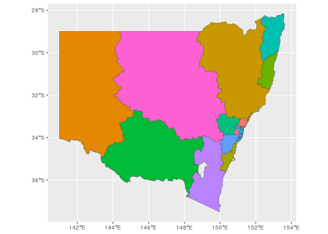
ggplot(nswgeo::nsw) +
geom_sf(fill = "white", data = nswgeo::australia) +
geom_sf(fill = "#9BCBEB", colour = NA) +
geom_sf(fill = NA, colour = "white", data = nswgeo::lhd) +
geom_sf(fill = NA, colour = "#002664", linewidth = .8) +
annotate(
"text", x = 144, y = -27, label = "New South Wales",
angle = -5, size = 5, fontface = "italic", colour = "#002664"
) +
coord_sf(crs = crs_gda2020_albers(), default_crs = crs_gda2020()) +
theme_minimal() +
theme(
panel.background = element_rect(fill = "grey97", colour = NA),
axis.title = element_blank(),
)
Alternatively, the data can be accessed through
{cartographer}:
library(cartographer)
head(covid_cases_nsw)
#> # A tibble: 6 × 5
#>   postcode lga       lhd                 year type
#>   <chr>    <chr>     <chr>              <int> <chr>
#> 1 2428     Mid-Coast Hunter New England  2022 A
#> 2 2761     Blacktown Western Sydney      2021 A
#> 3 2426     Mid-Coast Hunter New England  2022 B
#> 4 2324     Mid-Coast Hunter New England  2022 B
#> 5 2767     Blacktown Western Sydney      2021 A
#> 6 2427     Mid-Coast Hunter New England  2022 A

covid_cases_nsw |>
  dplyr::count(lga) |>
  add_geometry(lga, feature_type = "nswgeo.lga") |>
  ggplot() +
  geom_sf(aes(fill = n)) +
  geom_sf(fill = NA, data = map_sf("nswgeo.lga")) +
  scale_fill_viridis_b("Cases") +
  theme_void()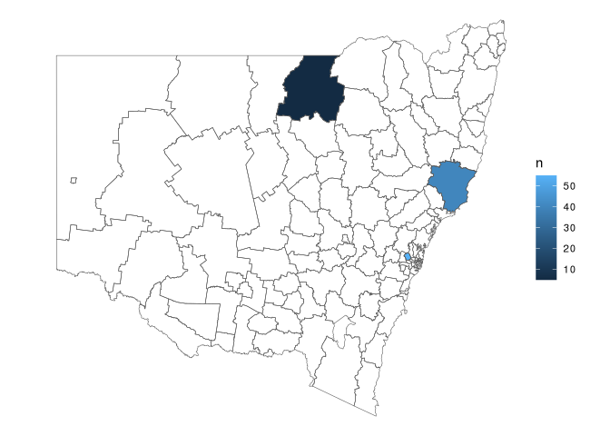
Some of the source datasets are very high resolution and would make
this package too large if they were bundled. Accordingly, most data has
been processed to reduce the resolution. You can see exactly what was
done by looking at the scripts in data-raw/, which also
help to download source data.
If you need higher resolution shapes, such as when zooming into specific postal areas, you’re better off using the original datasets directly.
strayr
helps with working with data from the Australian Bureau of Statistics
(ABS).absmapsdata
contains some processed ABS geospatial data.These binaries (installable software) and packages are in development.
They may not be fully stable and should be used with caution. We make no claims about them.